Projects

Nicobi Project

Overview

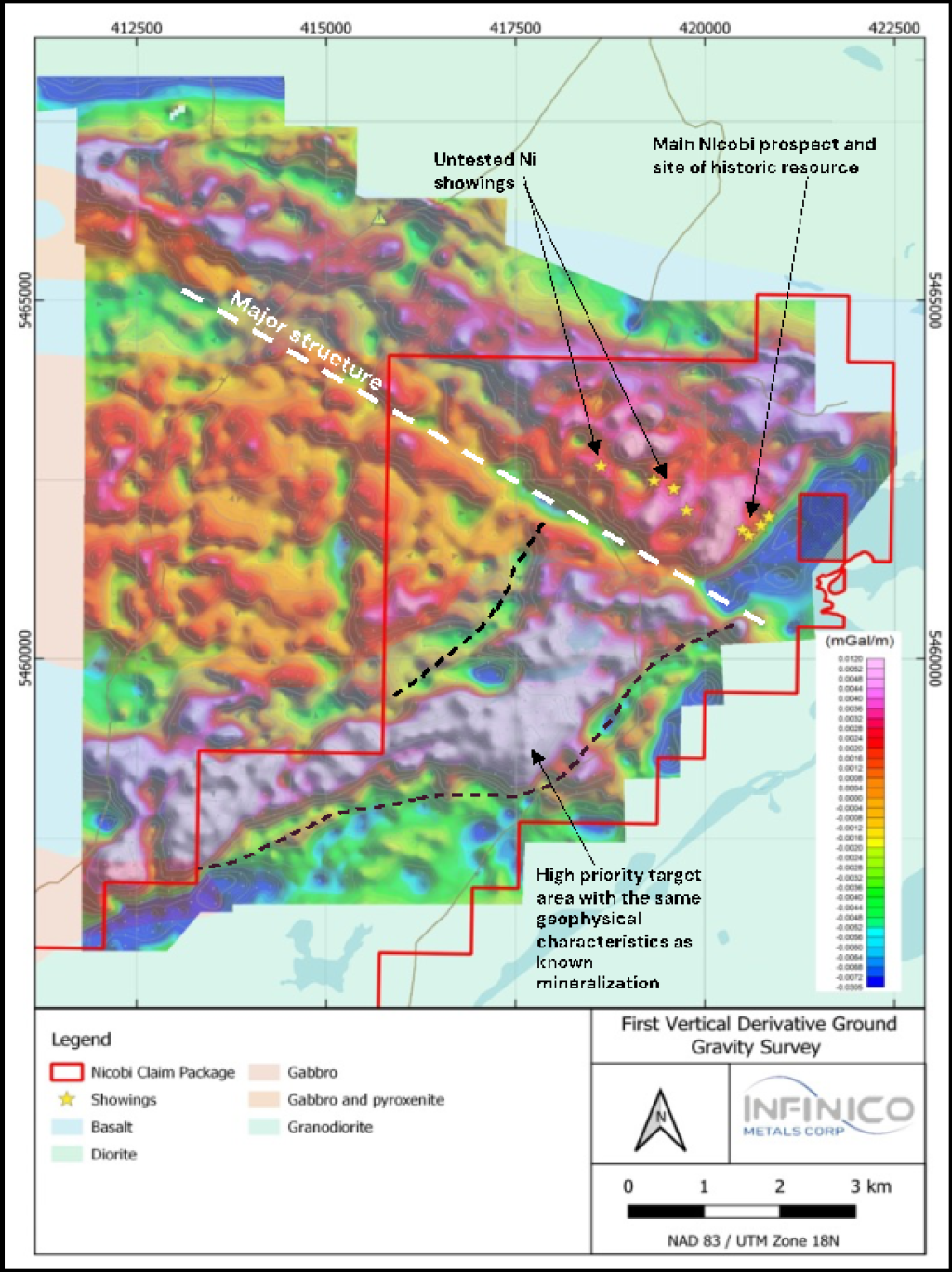
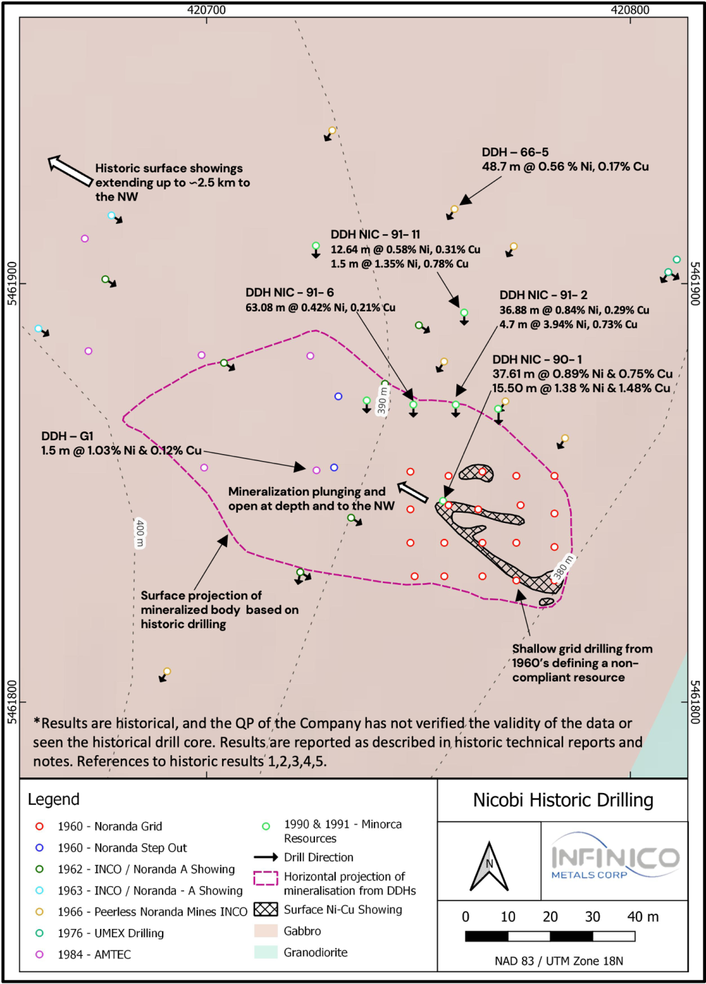
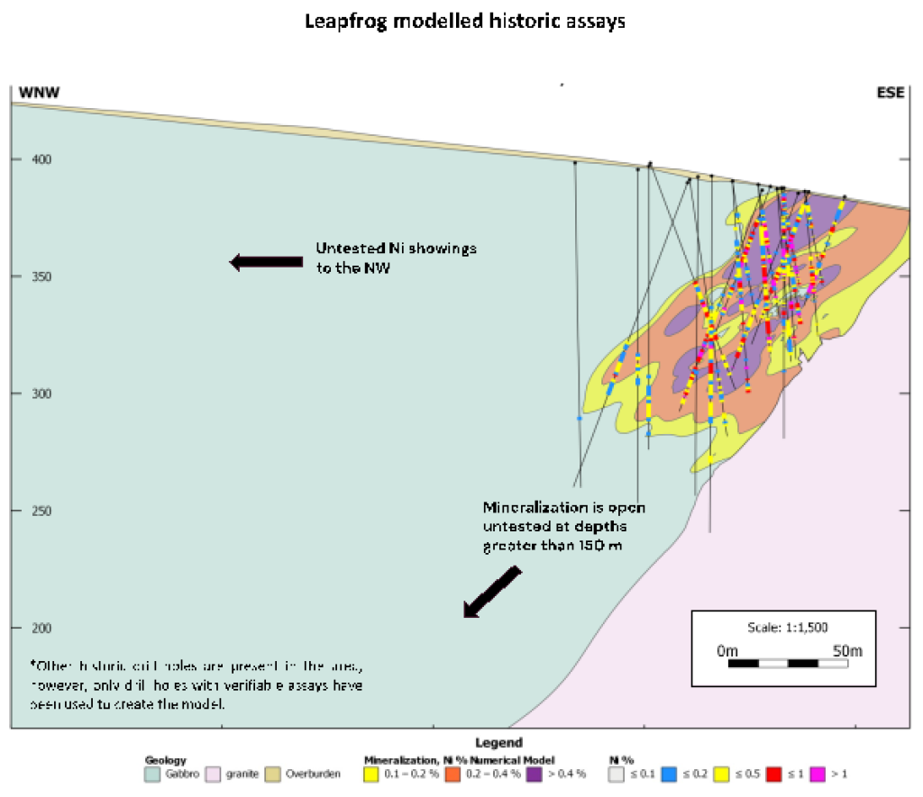
The Nicobi Project is an ortho-magmatic Ni-Cu-Co-3PGE project located within a mafic-to-ultramafic intrusion of the Abitibi Subprovince. Historical exploration drilling until the early 1990s targeted and revealed disseminated to massive sulphide mineralization. Parts of the property underwent systematic drilling in the 1960s, during which previous operators defined a non-compliant resource. A scout drilling campaign in 1991 intersected 37.61 metres at 0.75% Cu and 0.89% Ni from the surface. This was collared with a 70.0 m step out from the initial discovery, tapping into and opening mineralization in the distal parts of the intrusion. Various geophysical surveys were completed over the property, including a high-quality gravity survey as well as a modern Airbourne Time Domain Electromagnetic (TDEM) survey executed in 2008.

The Company has commenced reprocessing of historic drilling and geophysical data in 3D software to develop a comprehensive geological model and provide a better understanding of the known mineralization. Modelling of TDEM may also identify previously unrecognized or overlooked conductive features which can be directly targeted with future drilling. This work is expected to quickly fast-track the project so that the Company can commence field work in early 2024. Initial field work will include drilling and downhole electromagnetic surveying (DHEM). The drilling will aim to confirm historic grades and drill intersects, along with starting to test the strike and depth extent of the mineralized intrusion.

Location and Access

The Nicobi project is in the James Bay region, with excellent mining and exploration infrastructure along with plentiful technical expertise. The project is located 54 km ENE of Lebel-Sur-Quévillon and 3 hours drive of the mining hub of Val-d’Or. The project is fully accessible by road.

Geology

The Nicobi Project is an ortho-magmatic Ni-Cu-Co project located within a mafic-to-ultramafic intrusive complex of the Abitibi Sub-province. The property sits on the intersect of two major lineaments. Surface nickel showings are present across a 2 km strike and trend in a NW direction across the property. Historical exploration drilling on the main Nicobi showing from the 1960’s through to the early 1990s targeted and revealed disseminated to massive sulphide mineralization. Parts of the property underwent systematic drilling in the 1960s, during which previous operators defined a non-compliant resource. A scout drilling campaign in 1991 intersected magmatic nickel sulphide mineralization1, including:

  • 15.5 m @ 1.38% Ni & 1.48% Cu
  • 63.1 m @ 0.42% Ni & 0.21% Cu
  • 4.70 m @ 3.94% Ni & 0.73% Cu

Compilation of historic data and modelling of historic drilling suggests the mineralized body remains open down plunge to the NW and untested along strike in either direction. Furthermore, the project has never seen modern low-frequency high-power electromagnetics, despite the style of mineralization being highly receptive to this type of geophysical survey.

Disclaimer: Results are historical, and the QP of the Company has not verified the validity of the data or seen the historical drill core. Results are reported as described in historic technical reports and notes.

1 Minorca Resources Drilling 1990 - 1991, GM 51748 - Assessment Report on the Nicobi Lake Cu-Ni-Co Property, Le Tac Township, Quebec, NTS 32F/8 
2 Rapport de la campagne de dec. 1984 sur le depot nickel-cuivre, propriete Nicobi, GM42818
3 Peerless Canadian Exploration Limited Drill Reports, GM 20038
4 Geophysical and geotechnical compilation report on 1980 program, Nicobi lake project, GM 37748
5 Journal de sondages au diamant - diamond drill record, GM10502

Subscribe for Updates